


10 Hiking Trails near Calaveras Big Trees State Park
first prev 1 next lastShowing Hiking Trails within 50 miles Distance miles of 1170 CA-4, Arnold, CA 95223, USA City, Zip, or Address
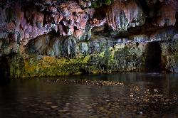
Natural Bridges
Sonora, California
17.9 miles SWNatural Bridges is well known among the locals of Calaveras County. Calavers itself has many caverns throughout the mountains, but most are fee based. Natural Bridges however, is open to the...
Hike, Swim
Gods Bath
Phoenix Lake-Cedar Ridge, CA, California
24.5 miles SEGod's Bath swimming hole in the Clavey River is a beautiful and popular location to take a dive in. However, the hike to get there is about one mile of rock climbing. The trailhead begins on...
Hike, Swim
New Hogan Lake
Valley Springs, California
28.3 miles WBackpack, Camp, Hike, and Swim near Valley Springs, California
Backpack, Camp, Hike, Swim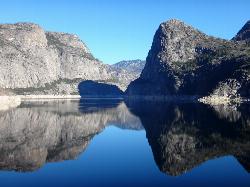
Hetch Hetchy Reservoir
Groveland, California
36.5 miles SELocated thirty minutes outside Yosemite Valley, Hetch Hetchy has the longest hiking season in the park. It's home to the O'Shaughnessy Dam and Wapama Falls. Since...
Backpack, Hike 4.7 mi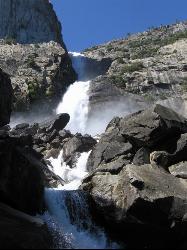
Wapama Falls
Groveland, California
36.5 miles SEA 5 mile hike along the shoreline of the Hetch Hetchy reservoir will take you to one of Yosemite's famous waterfalls. The hike to the fall is moderate, takes about 2.5-5 hours to...
Backpack, Hike 0.4 mi
Glen Alpine Falls
South Lake Tahoe, California
43.5 miles NAs you drive up to the falls, take a look around. The views are spectacular. The drive can feel long, but the waterfall is peaceful and worth the drive. This waterfall is considered one of the...
Hike
Harden Lake
Big Oak Flat, Yosemite National Park
45.7 miles SEThe hike to Harden Lake at Yosemite is essentially a long walk. Much of the trail is walking down Tioga Road, an old gravel street that has been part of Yosemite since its foundation. The trail is...
Backpack, Hike
Crane Flat
Big Oak Flat, Yosemite National Park
46.0 miles SECrane Flat Campground is a meadow and forest between Tuolumne and Merced Groves of Giant Sequoias. The campground is 30 minutes outside Yosemite Valley, has restrooms and picnic...
Backpack, Camp, Hike, Snowshoe 0.7 mi
Lukens Lake
Tuolumne Meadows, Yosemite National Park
48.0 miles SELukens Lake is a small lake in the White Wolf area of Yosemite National Park. The hike is a short, 1.6 mile walk through a forest to the secluded lake surrounded by trees and a small...
Hike, Swim
Hite Cove Trail
El Portal, California
49.2 miles SEThis hike is popular among wildflower enthusiasts. Located in Yosemite National Park, Hite Cove trail is one of the areas that blooms earliest for wildflowers. While areas in the high country...
Hike, Swim


