


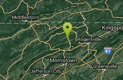
Gabe's Creek Falls
Big Laurel, Kentucky
| Address: | Abner Branch Rd, Bledsoe, KY 40810, USA |
| GPS: |
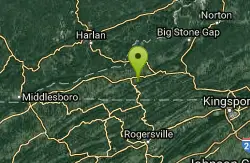
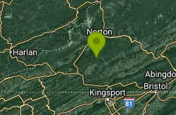
36°57'58.6"N 83°15'2.5"W Maps | Directions |
| State: | Kentucky |
Swim
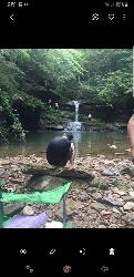
Gabe's Branch Falls is a picturesque remote swimming hole that even some locals don't know about. The bright blue pool of water is surrounded by a ring of short cliffs with a waterfall cascading down them. The cliffs have small overhangs in places making almost cave like coves to swim in. The water here is nice and cool being fed by the cold water, perfect temperature for a hot summer day. This beautiful spot is never crowded, and you will likely have the place to yourself. Clothing is optional here, and it is a popular skinny dipping spot.
The hike to the falls is a short, slick trail that leads from the dirt road where you'll park to reach the falls. This trail is easy to hike, but visitors should be cautious they don't slip and fall. There is no established trail or signs, but the path is clearly worn by visitors.
To reach Gabe's Branch Falls visitors should turn right from RT 2009 to RT 2008 and then take a right on Abner road. Abner road is a dirt road that is not signed. From here visitors will cross a little bridge and then go 0.7 miles to a small gravel road where they can pull off and park. For more detailed directions visit this link.
More Information
- Plan Ahead and Prepare
- Travel & camp on durable surfaces
- Dispose of waste properly
- Leave what you find
- Minimize campfire impacts
- Respect wildlife
- Be considerate of other visitors
Directions
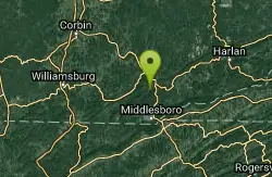
From Big Laurel, Kentucky
- Head west on State Hwy 221 toward Cr-1041E (0.1 mi)
- Turn right onto State Hwy 2008 (3.2 mi)
- Turn left onto Abner Branch RdDestination will be on the right(0.7 mi)
to add photos & videos and suggest edits
Edit Review
Delete Review
5/6/23 5:20 pm
I followed the directions on my phone, drove 5 1/2 hours all the way to the middle of backwoods nowhere, and when I finally came to Abner Branch Rd in Bledsoe, KY, all I found was a bunch of gated-off dirt roads and "No Trespassing" signs. Don't bother; it's a waste of time and gasolene at best and a potential run-in with the law at worst, unless someone else knows another way to Gabe's Branch Falls that is NOT closed to the public.
Reply
Edit Review
Delete Review


Other Swimming Holes Nearby
Add Location
Blue Hole Jonesville
Jonesville, Virginia
22.6 miles SECLOSED. This is on private property with no trespassing signs clearly displayed.
Swim
Clear Creek
Lebanon, Kentucky
31.1 miles SWClear Creek is a wide multi-purpose trail that follows a beautiful creek. This trail is open to hikers, runners, mountain bikers, fishermen, horse back riders and off-road vehicles under 50 inches....
Hike, Horseback, Mountain Bike, Swim 6.6 mi
Devil's Bathtub
Duffield, Virginia
34.8 miles EThe Devil's Fork Loop Trail is a difficult hike that has become popular because of it's unique water features. The trail is 7.2 rocky miles with several steep areas. Along the hike there are...
Hike, Swim
Elrod Falls
Thorn Hill, Tennessee
36.4 miles SSwim near Thorn Hill, Tennessee
Swim
Little Stony Falls Area
Dungannon, Virginia
43.9 miles ELarge pool at bottom of 25 foot falls, with rocks around. Bathing suits: Unknown (probably optional)
Swim


