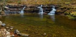
Falls Of Dismal
Pearisburg, Virginia
| GPS: |
37°11'18.1"N 80°54'1.3"W Maps | Directions |
| State: | Virginia |
Swim
This from a visitor in 2007: "This area is in the National Forest, but is very secluded due to the tree coverage. Some very large flat rocks around water area, for laying out, swimming area is very private now, over the last few years, the tree coverage hides it from the road nearby. You can hear traffic if any comes, most goes on by. The road is at the top of the hill, and makes a 90 degree turn around area, although, swimming and other areas are now very secluded and private due to trees growing, hiding from road, which is a dirt/gravel road into national area, and campgrounds. Not a lot of traffic on this road, almost need to know about it, to get there. Very nice for swimming, playing, laying out, secluded, private area."Courtesy of swimmingholes.org
Bathing suits: Optional
More Information
Directions
From Pearisburg, Virginia
- Head south on VA-100 S/N Main St toward Wenonah AveContinue to follow VA-100 S(10.4 mi)
- Turn right onto VA-42 W (10.2 mi)
- Turn right onto State Rte 606 (0.9 mi)
- Turn right onto State Rte 671 (1.0 mi)
- Continue onto Dismal Creek RdDestination will be on the right(0.2 mi)

Other Swimming Holes Nearby

Narrows Town Park
Narrows, Virginia
6.3 miles NWSwim near Narrows, Virginia
Swim
Blacksburg Hole
Newport, Virginia
16.6 miles ESwim near Newport, Virginia
Swim
Goshen Pass Area
Max Meadows, Virginia
21.0 miles SSwim near Max Meadows, Virginia
Swim
Foster Falls
Max Meadows, Virginia
21.0 miles SSwim near Max Meadows, Virginia
Swim
Camp Creek Area
Cabins, West Virginia
21.1 miles NWSwim near Cabins, West Virginia
Swim
Brush Creek Falls
Athens, West Virginia
21.1 miles NWBrush Creek Falls is a beautiful waterfall in Brush Creek Nature Preserve. This is a popular location for photographers and nature lovers, as the waterfall makes a perfect backdrop for a gorgeous...
Swim
Dark Horse Hollow
Wytheville, Virginia
21.3 miles SWWater play/swimming hole at recreation area in Jefferson National Forest. Sandy beach. Easy loop hiking trail. Warning: water may be still, shallow and appear dirty late in the...
Swim
Cascade Falls
Pembroke, Virginia
21.7 miles NESwim near Pembroke, Virginia
Swim
Campbell Falls
Camp Creek, West Virginia
25.4 miles NWCampbell Falls is one of the many waterfalls resting in Camp Creek, West Virginia. Campbell Falls is 15 feet tall and 40 feet wide (depending on water levels), and powerful. The flow of the...
Camp, Hike, Mountain Bike, Swim
Sandstone Falls
Shady Spring, West Virginia
39.4 miles NSwim near Shady Spring, West Virginia
Swim
Anvil Rock
Alderson, West Virginia
40.9 miles NESwim near Alderson, West Virginia
Swim
Glade Creek Area
Masontown, West Virginia
44.3 miles NBeautiful creek and gorge that runs into New River, has a 6+ mile hiking trail alongside. Has many swimming holes along this length. The Glade Creek gorge and trail can be accessed...
SwimNearby Campsites

Mash Fork Falls
Camp Creek, West Virginia
25.4 miles NWMash Fork Falls is a beautiful little waterfall flowing in Camp Creek, West Virginia. Although it is not particularly large, it is beautiful and powerful in it's own unique...
Camp, Hike, Mountain Bike
Campbell Falls
Camp Creek, West Virginia
25.4 miles NWCampbell Falls is one of the many waterfalls resting in Camp Creek, West Virginia. Campbell Falls is 15 feet tall and 40 feet wide (depending on water levels), and powerful. The flow of the...
Camp, Hike, Mountain Bike, Swim


