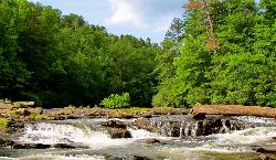
Emery Creek Trail
Chatsworth, Georgia
| Address: | Emery Creek Trail Trailhead, 5925 Old CCC Camp Rd, Chatsworth, GA 30705, USA |
| GPS: |
34°48'44.7"N 84°39'5.9"W Maps | Directions |
| State: | Georgia |
| Trails/Routes: | 5.6 mi |
Hike
The Emery Creek Trail, located near Chatsworth, Georgia, showcases the beauty of Northern Georgia with two beautiful waterfalls along the way as you cross through both Emery Creek and Holly Creek, where there is a small swimming hole just a half mile from the trail. Hikers are required to cross both creeks multiple times as they hike along the trail. Prepare accordingly with water shoes and quick drying clothes. The trail itself is about 5.9 miles long and is an out and back style trail. The best times to hike the Emery Creek trail are from March to September.
The two waterfalls mentioned above are the Upper and Lower Emery Creek Falls. Both waterfalls are worth the near 6 mile hike and are unique in their own way. The lower falls are small but feature beautiful trees surrounding the falls that enhance its beauty. The main falls are the upper falls which is much larger and features a cascading waterfall that resembles the Fountain of Youth.
Be cautious about hiking the trail in the early spring months because the water levels may be higher than at any other time of the year. With the water levels being higher, hikers face more danger when they cross the river. In the first crossing, the rocks at the bottom of the creek are sharp and slippery which could cause a slip and fall injury, especially if the water is moving quickly. Use caution during the first crossing, but the other creek crossings along the hike are much easier to handle.
The Emery Creek trail is a great spot to keep your family entertained all summer long! With spots to swim, hike, and see two beautiful waterfalls, Emery Creek has the complete package for any summer adventure.
More Information
Be courteous, informed, and prepared. Read trailhead guidelines, stay on the trail, and don't feed the wildlife.
Read MoreDirections
From Chatsworth, Georgia
- Head south toward S 3rd Ave (118 ft)
- Turn left toward S 3rd Ave (89 ft)
- Turn left onto S 3rd Ave (0.7 mi)
- Turn right onto Old Federal Rd N (0.7 mi)
- Slight right onto Hyden Tyler Rd (2.8 mi)
- Continue onto Old CCC Camp RdDestination will be on the left(5.8 mi)
Trails
Distance ?
5.6 miles Round TripElevation Gain ?
702 feetReal Ascent ?
1,070 feetReal Descent ?
368 feetAvg Grade (3°)
5%Grade (-23° to 17°)
-42% to 30%Elevation differences are scaled for emphasis. While the numbers are accurate, the cut-away shown here is not to scale.
Other Hiking Trails Nearby

Edge Of The World
Dawsonville, Georgia
36.6 miles SEEdge of the World, known by the locals as the Amicalola River Rapids, is located in Dawsonville, Georgia. It is a popular swimming hole in the greater Atlanta area that attracts visitors from...
Hike, Swim
Baby Falls
Tellico Plains, Tennessee
44.6 miles NEThe Tellico River is the home of the Baby Falls waterfall/swimming hole. Although it is beautiful at all times of the year, fall has been said to be one of the most beautiful and favorite times for...
Hike, Kayak, Swim, Whitewater
Davis Branch
Tellico Plains, Tennessee
44.9 miles NEDavis Branch is a beautiful campground located in Tennesse by the beautiful Tellico River. Here you can camp, hike, and explore the river. The campground has six different campsites all offering...
Camp, Hike, SwimNearby Campsites

Vogle State Park
Blairsville, Georgia
41.6 miles EVogel State Park is a 233-acre or 94 hectares state park located at the base of Blood Mountain in the Chattahoochee National Forest. It became one of the first two parks in Georgia when it founded a...
Camp, Canoe, Swim
Davis Branch
Tellico Plains, Tennessee
44.9 miles NEDavis Branch is a beautiful campground located in Tennesse by the beautiful Tellico River. Here you can camp, hike, and explore the river. The campground has six different campsites all offering...
Camp, Hike, Swim


