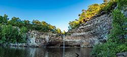
Desoto Falls
Mentone, Alabama
| Address: | 984 Co Rd 613, Mentone, AL 35984, USA |
| GPS: |
34°32'57.1"N 85°35'24.1"W Maps | Directions |
| State: | Alabama |
Waterfalls Trails State Park
Hike and Swim
If you visit Desoto State Park, this is one of the must-see sights! Desoto Falls is rich in history and legends. It's a scenic beauty located within Desoto State Park and is easily accessible from Lookout Mountain Parkway.
Desoto Falls is the tallest and most popular waterfall in Alabama and was named after a Spanish explorer, Hernando De Soto. The 104-foot waterfall has formed its own small canyon, although it is believed that parts of the falls are manmade. There are also legends about the caves that are found around the falls. It has been said that a piece of Hernando De Soto's armor from his 1500's expedition was found near the falls. For thousands of years, De Soto Falls has been a landmark, especially visited by Native Americans long before the first European explorers arrived. The waterfall was special to the Cherokee Indians who once lived in this area of Alabama
If legends are true, De Soto was here before Columbus came to America. Local folklore has it that a few of the small caves below the waterfall were part of a fort built by Welsh explorers, but research findings say that it was probably a structure built by American Indians in the Woodland era.
The upper falls can be seen by all visitors from the railed overlook near the parking lot. To see the lower falls, you need to walk down cement steps which could be difficult for young children and the elderly.
The amount of water rushing from the falls depends on how much rainfall there has been. In the winter and early spring, the water levels are high, while water levels are very low during the summer and early fall.
More Information
Be courteous, informed, and prepared. Read trailhead guidelines, stay on the trail, and don't feed the wildlife.
Read MoreDirections
From Mentone, Alabama
- Head west on AL-117 N toward S Cool St (1.3 mi)
- Turn left (1.0 mi)
- Turn left onto Co Rd 613 (0.8 mi)
- Continue onto Desoto Falls Road (0.3 mi)
- Continue onto Co Rd 613Destination will be on the right(164 ft)
Other Swimming Holes and Hiking Trails Nearby

Desoto Area
Oxford, Alabama
3.7 miles SWSwim near Oxford, Alabama
Swim
Desoto State Park
Fort Payne, Alabama
3.9 miles SWDesoto State Park is located on the gorgeous Lookout Mountain in the scenic northeast of Alabama. It is conveniently located 8 miles northeast from Fort Payne. With many rushing waterfalls...
Hike, Kayak, Mountain Bike, Rock Climb, Swim
Little River Canyon Area
Oxford, Alabama
10.9 miles SLittle River Canyon is one of the deepest gorges East of the Mississippi. It is very beautiful but hiking trails are not yet well developed. Much of the canyon is very hard to...
Swim
Blue Hole Pigeon
LaFayette, Georgia
17.7 miles NESmall but deep blue-green spring-fed hole, maybe entrance to underground cave. Caving and rock climbing nearby also. You must have a GORP Georgia Outdoor Recreational Pass to...
Swim
Guntersville Area
Oxford, Alabama
26.8 miles SWSwim near Oxford, Alabama
Swim
Conasauga Area
Cave Spring, Georgia
33.8 miles SESwim near Cave Spring, Georgia
Swim
Cave Spring
Cave Spring, Georgia
33.8 miles SECave Spring is a spring that originates in a cave and flows into a man-made swimming pool/lake the shape of Georgia (!) in Rolator Park the town of Cave Springs. Very interesting...
Swim
Walls Of Jericho
Estillfork, Alabama
42.1 miles NWVery spectacular wild, scenic area with massive limestone amphitheatre in the Southern Cumberland Plateau (on the border between TN and AL) where water cascades 200 feet over...
Swim
Grundy Forest Area
Tracy City, Tennessee
44.0 miles NSwim near Tracy City, Tennessee
Swim
Farmers Lake
Cohutta, Georgia
46.0 miles NESwim near Cohutta, Georgia
Swim
Rockmart
Rockmart, Georgia
49.4 miles SEA deep swimming hole in a creek near the Rockmart quarry in the town of Rockmart. You can jump off the concrete base of an old pump station into a dammed portion of Thompson Creek....
Swim


