Cinder Cone and the Fantastic Lava Beds
Lassen County, California
| Address: | Butte Lake, Lassen County, CA, United States |
| GPS: |
40°33'53.7"N 121°18'6.9"W Maps | Directions |
| State: | California |
Trails National Park
Hike
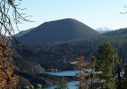
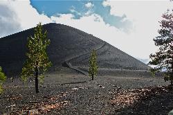
One of the four types of volcanos found in Lassen Volcanic National Park, Cinder Cone stands at 6,907 ft elevation and 750 ft above the surrounding landscape. Cinder Cone was formed in the 1600's, though lava flows at its base caused the then active volcano to die down. Today, Cinder Cone is not active, and is a hike that allows visitors to experience a cinder cone first hand. Along the way, hikers will see the Painted Dunes and the Fantastic Lava Beds.
The trail begins from the Butte Lake parking lot and is about four miles round trip, taking approximately 3 hours to hike it all. Similar to hiking in sand, the trail is very loose terrain and can be very taxing regardless of how short of a hike it seems. When hikers reach the top they will have the option to take in the view from the summit or continue down into the crater of the cinder cone.
From the top hikers will see the Painted Dunes, which were formed after the erruption of the cinder cone, and as the lava cooled off, left behind orange hills at the base of the cinder cone. The Fantastic Lava Beds are also visibile and create stark contrast from the forested landscape. The lava beds actually helped to form the two lakes in the area, damming the lakes when the lava beds were first created.
More Information
Be courteous, informed, and prepared. Read trailhead guidelines, stay on the trail, and don't feed the wildlife.
Read MoreDirections
From Lassen County, California
- Head north on Peppermint Dr toward Merrillville Rd (0.2 mi)
- Turn right onto Merrillville Rd (3.9 mi)
- Turn right onto CA-139 S (15.1 mi)
- Turn right onto Main St (1.0 mi)
- Continue onto CA-36 W/Hillcrest RdContinue to follow CA-36 W(5.1 mi)
- Turn right onto CA-44 W (34.9 mi)
- Turn left onto Forest Rte 32N21Parts of this road may be closed at certain times or daysDestination will be on the left(6.6 mi)
Other Hiking Trails Nearby

Lassen Volcanic National Park
Redding, California
7.9 miles SWLassen Volcanic National Park is home to smoking fumaroles, meadows freckled with wildflowers, clear mountain lakes, and numerous volcanoes. Jagged peaks tell the story of its eruptive past while...
Backcountry Ski, Camp, Canoe, Hike, Horseback, Hot Springs, Mountain Bike, Snowshoe
Kings Creek Falls
Shasta County, California
11.0 miles SWWhile Lassen Volcanic National Park is known for its wide variety of hydrothermal features, there are a few other sights in the park worth seeing, including Kings Creek Falls. The trail is accessible...
Hike, Horseback
Lassen Peak
Mineral, California
12.4 miles SWLassen Peak is the largest plug dome volcano in the world and the second tallest volcano in Northern California. It is situated in Lassen Volcanic National Park, one of the few places in the world...
Backpack, Hike
Bumpass Hell
13.1 miles SW
Bumpass Hell is the largest collection of hydrothermal features in Lassen Volcanic National Park. The overall 3 mile round trip hike takes visitors around some of the hottest and largest features in...
Hike 0.3 mi
Burney Falls
Burney, California
36.0 miles NWBurney Falls has been considered one of the most spectacular waterfalls in the state. It stands at 129 feet tall and is coated by curtains of green fern. The best part about this waterfall, for many...
Hike


