


Apache Wash Trail
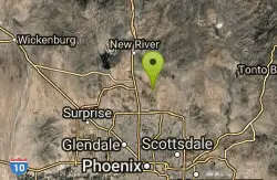
Phoenix, Arizona
| Address: | ~Paseo Pathway, Phoenix, AZ 85085, USA |
| GPS: |
33°45'50.2"N 112°2'57.7"W Maps | Directions |
| State: | Arizona |
| Trail Length: | 3.50 miles |
| Elevation Gain: | 108.00 feet |
| Hike Difficulty: | Intermediate |
| Trail Type: | Out & Back |
Pet Friendly
Hike
Start west on Ocitillo to Ridgeback north till you get to the crossing of Sidewinder then head west. Keep on Sidewinder toil you come to the crossing of Octillio and head east back to trailhead. Moderate hike and lot of ups in the beginning but don't be fooled by the flat landscape returning. Courtesy of AllTrails.com
More Information
Add ResourceBe courteous, informed, and prepared. Read trailhead guidelines, stay on the trail, and don't feed the wildlife.
Read More- Plan Ahead and Prepare
- Travel & camp on durable surfaces
- Dispose of waste properly
- Leave what you find
- Minimize campfire impacts
- Respect wildlife
- Be considerate of other visitors
Directions
From Phoenix, Arizona
- Head west on W Washington St toward 1st Ave (1.2 mi)
- Continue onto W Adams St (0.8 mi)
- Turn right onto N Black Canyon Hwy (75 ft)
- Take the ramp on the left onto I-17 N/US-60 WContinue to follow I-17 N(22.2 mi)
- Take exit 222 for Dove Valley Rd (1.1 mi)
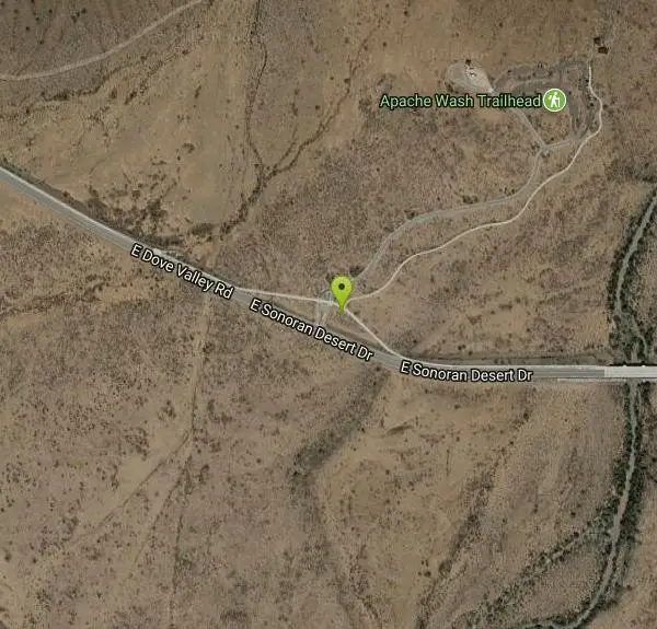
- Turn right onto W Dove Valley Rd (5.1 mi)
- Continue onto E Sonoran Desert Dr (499 ft)
- Turn left (148 ft)
Other Hiking Trails Nearby

Sidewinder, Apache Vista, Ocotillo Loop Trail
Phoenix, Arizona
0.3 miles NEThis is an excellent loop that is very well maintained, well sign posted and if you include the vista summit trail, a moderate work out. Massive Car Park, good restrooms, and plenty of...
Hike, Horseback, Mountain Bike
Ocotillo/Ridgeback/Sidewinder Loop Trail
Phoenix, Arizona
0.4 miles NEGreat moderate loop which includes a summit, great views and Classic Sonoran Desert scenery. Multiple access points and other connecting trails allows for the loop to be changed if...
Hike, Horseback, Mountain Bike
Bobcat Trail - Sonoran Preserve
Phoenix, Arizona
3.0 miles WBobcat Trail is a short, easy trail, often used for connecting to other bigger trails in the Sonoran Desert Preserve. This is a 2 mile out-and back trail. There isn't much of a parking...
Hike
Sidewinder-Ocotillo-West Loop
Phoenix, Arizona
3.1 miles NWThis loop starts at Carefree Hwy and 7th Ave, be aware there is limited parking at the trailhead. The Ocotillo part of the trail is relatively flat and the Sidewinder part has some good...
Hike, Horseback, Mountain Bike
Tower Road - Sonoran Preserve
Phoenix, Arizona
3.1 miles NWShort and steep (.6 mile each way) out and back asphalt road to the radio tower.
Hike
Dixie Summit Trail
Phoenix, Arizona
3.2 miles SWA steep and difficult short trail using many switchbacks to get to the summit. You will be rewarded with spectacular views of the surrounding area.
Hike
Western Vista Trail
Phoenix, Arizona
3.2 miles SWFairly difficult short Trail to one of the summits on the Dixie Mountain Loop. Great views from the top as well as a birds eye view of the gravel pit below.
Hike 2.8 mi
Desert Tortoise
Phoenix, Arizona
3.2 miles SWAt just over a mile long, Desert Tortoise is a doubletrack connector to the Valle Verde Trail. Very good hiking area with a good range of difficulty levels. Starts with a short climb from the...
Hike, Mountain Bike
Dixie Mountain Loop Trail
Phoenix, Arizona
3.2 miles SWThe main loop trail at Phoenix's Sonoran Preserve provides plenty of options for either a short walk or a longer hike. The elevation gain is accumulated through small ups-and-downs along the...
Hike, Horseback, Mountain Bike
Dixie Mountain Loop with Two Summits
Phoenix, Arizona
3.2 miles SWHike, Horseback, and Mountain Bike near Phoenix, Arizona
Hike, Horseback, Mountain Bike
Hawk's Nest Trail and Dixie Mountain Loop
Phoenix, Arizona
3.2 miles SWModerate Trail providing access from the Car Park to all other trails. Directly links to Desert Tortoise Trail and Dixie Mountain Loop. Good hiking shoes/boots recommended....
Hike, Horseback, Mountain Bike
Hawk's Nest/Desert Tortoise/Dixie Mountain Loop
Phoenix, Arizona
3.2 miles SWA nice moderate trail through great desert scenery crossing creeks and twisting and turning around the hills. Provides a loop opportunity between Hawk's Nest Trail, Valle Verde Trail,...
Hike, Horseback, Mountain Bike
Union Peak Loop
Phoenix, Arizona
3.2 miles SWHike near Phoenix, Arizona
Hike
Clay Mine Trail
Cave Creek, Arizona
4.7 miles NClay Mine Trail is a 1.6 mile out-and-back, beginner friendly trail in Cave Creek Regional Park. This is a trail that is very close to the Visitor Center. It's not too difficult but there...
Hike 5.8 mi
Go John Trail
Cave Creek, Arizona
5.5 miles NEThe Go John Trail is a 5.8 mile loop trail outside of Cave Creek, Arizona, that is moderately trafficked, used by both hikers and mountain bikers. It is an excellent opportunity to view the desert...
Hike, Horseback, Mountain Bike
Palisade to Basalt to Circumference Trail Loop
Phoenix, Arizona
5.8 miles WHike near Phoenix, Arizona
Hike
Deem Hills Inner Loop
Phoenix, Arizona
5.8 miles WHike and Mountain Bike near Phoenix, Arizona
Hike, Mountain Bike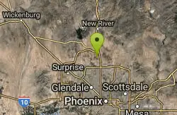
Deem Hills East Trail
Phoenix, Arizona
5.8 miles WDeem Hills is one of the newer parks in Phoenix to open (2010) and as such a lot of people still don't know it's there. This means that it has much more of a secluded feel then some of...
Hike
Reach 11 Trail
Phoenix, Arizona
5.9 miles SHike near Phoenix, Arizona
Hike
Scarlett Canyon
Phoenix, Arizona
6.1 miles SScarlett Canyon trail (not officially named) is an unmarked trail adjacent to the Scarlett Canyon residential neighborhood. This is a 3 mile loop trail considered to be easy to...
Hike, Horseback, Mountain Bike, Rock ClimbNearby Campsites

Lower Salt River Nature Trail
Fort McDowell, Arizona
27.0 miles SEThe Lower Salt River Nature Trail is a scenic walk to take at the Tonto National Forest. This trail provides stunning views as you walk alongside the Salt River. This rustic trail is older and less...
Camp, Hike
Buckhorn Campground Nature Trail
Apache Junction, Arizona
31.9 miles SECamp and Hike near Apache Junction, Arizona
Camp, Hike
Verde Hot Springs
Camp Verde, Arizona
45.1 miles NEVerde Hot Springs are a few natural hot spring pools located along the Verde River, near Sedona, Arizona. Once a resort, now all that remains are the foundations and the hot pools...
Camp, Hike, Hot Springs


